El Niño 2026: NASA satellites capture massive surge of warm water across the Pacific |
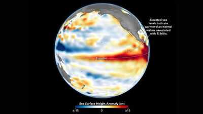

A vast stretch of the Pacific Ocean has begun showing signs of a powerful shift beneath its surface, with satellite observations revealing a growing bulge of unusually warm water spreading across the equatorial region. From space, the change appears as an enormous band of elevated sea levels extending from the central Pacific towards the coast of South America. While it is not a wave in the traditional sense, the feature has drawn attention because of its sheer scale and the amount of heat it represents.According to NASA, the developing El Niño event strengthened during early June, with satellite measurements detecting higher-than-normal sea surface heights across large sections of the tropical Pacific. The observations were gathered by the Sentinel-6 Michael Freilich satellite, which monitors subtle changes in ocean height from orbit and offers scientists a way to track how heat is moving through the world’s oceans.
NASA satellites track growing El Niño through rising Pacific sea levels
The red-coloured regions highlighted in NASA’s latest sea level maps point to areas where ocean waters are standing higher than average. That rise may seem small when measured in centimetres, but across thousands of kilometres of ocean it signals something much larger.Warm water expands. As temperatures increase, the ocean occupies more space, causing the surface to lift slightly. Scientists, therefore, treat unusual increases in sea level as one of the clearest indicators that excess heat is building within the ocean.According to NASA, those elevated waters have become increasingly visible across the central and eastern Pacific, confirming that El Niño conditions are becoming established. The pattern was already evident several days before the US National Oceanic and Atmospheric Administration formally declared the arrival of El Niño on 11 June.
Kelvin waves are pushing warm Pacific Ocean waters eastward
What satellites are capturing today began months earlier beneath the ocean’s surface. According to NASA, large bodies of warm water known as Kelvin waves started moving eastward across the Pacific during spring. These waves are not the towering walls of water associated with storms or tsunamis. Instead, they are broad pulses of heat travelling through the upper layers of the ocean.As trade winds weakened and temporarily reversed direction, warm water that had accumulated in the western Pacific was pushed eastward. The process allowed heat to spread towards the Americas, deepening the warm surface layer and disrupting the normal flow of cooler water from below. That movement is important because it determines how much energy becomes available to influence weather patterns around the globe.
Hidden Pacific Ocean heat could determine the strength of El Niño
Surface temperatures often receive the most attention during El Niño events, yet they only reveal part of the story. According to NASA, sea surface height measurements offer a different perspective because they help scientists estimate how much heat is stored beneath the surface. A thin layer of warm water may raise temperatures temporarily without producing major climate impacts. A deeper reservoir of warmth, however, can sustain atmospheric changes for months.The satellite data suggest that substantial heat has accumulated below the Pacific’s surface, which is one reason researchers are watching developments closely. The ocean is not simply warming at the top; it is storing energy through a thicker layer of water. That hidden heat can shape rainfall, drought patterns and storm activity far beyond the Pacific basin itself.
NASA finds similarities between the current El Niño and 1997
One aspect of the latest observations has attracted particular interest among scientists. According to NASA, conditions in the western Pacific during early June resembled patterns seen in 1997, the year one of the strongest El Niño events on record emerged. Satellite specialists studying the data noted similarities in the amount of heat present and the way warm water was organised across parts of the ocean.The comparison comes with an important caveat. Conditions farther east have not yet matched what was observed during the same stage of the 1997 event. Fewer Kelvin waves had reached the eastern Pacific by early June, suggesting the current event still has ground to cover before reaching the intensity associated with that historic year.Even so, additional warm-water pulses were continuing their journey across the Pacific, indicating that strengthening remained underway.
NASA satellites show El Niño continuing to gain strength
The coming weeks are expected to determine whether this developing El Niño grows into one of the more significant events of recent decades. Reportedly, the latest satellite observations show a Pacific Ocean that is still evolving rather than settling into a fixed state. New waves of subsurface warmth continue to move eastward, feeding the growing reservoir of heat already detected from space.For countries around the Pacific Rim, the outcome matters. El Niño has long been linked to shifts in rainfall, drought and seasonal weather patterns across several continents. Its influence can extend from the Americas to Australia and parts of Southeast Asia.For now, scientists remain focused on what the satellites are seeing: a massive build-up of heat spreading across the Pacific, lifting the ocean surface and signalling that one of Earth’s most influential climate cycles is gathering strength once again.