


A routine dredging project on the Lower Columbia River has become a major long-term experiment to see whether dredged sediment can be used to restore lost wildlife habitat.In October 2020, engineers pumped 225,000 cubic yards of sediment from St. Helens Bar and placed it along the Washington side of the river between miles 86 and 84.5. Instead of dumping the material in deep water or removing it from the area, workers carefully shaped it into four small islands and a side channel known as the Woodland Islands.Scientists are now studying these artificial islands to find out whether they can provide important habitat for young salmon.
Restoring lost habitat in a busy river
The Lower Columbia River is an important transportation route. Its deep shipping channel stretches about 110 miles and carries more than 40 million tons of cargo each year.To keep the river deep enough for large commercial ships, crews must remove about 6 to 8 million cubic yards of sediment from the riverbed every year.At the same time, the river has lost much of its natural habitat. Dams, dikes, and other shoreline structures have changed the way water and sediment move through the river. As a result, about 75 per cent of the Lower Columbia River’s natural tidal habitat has disappeared.The loss of shallow-water areas has been especially harmful to salmon and other native fish. Young salmon use these slow-moving, shallow areas while traveling toward the Pacific Ocean. These areas give them places to rest, hide from predators, and find food such as insects and other small organisms.Without enough estuary habitat to feed and grow stronger before reaching the ocean, young salmon have a lower chance of surviving.
Turning dredged sediment into islands
The Woodland Islands area originally contained older deposits of sediment placed near timber pile dikes in the late 1800s. After the placement of sediment stopped in the 1970s, erosion gradually broke the area apart and turned what had once been a peninsula into several small, eroding islands.The 2020 project was designed to slow that erosion while creating new habitat.The 225,000 cubic yards of sand and silt created about seven acres of new land. The project also reconnected parts of the island chain and created a protected side channel.Workers added compost above the waterline to help plants grow in the new soil. Through early 2023, crews planted native grasses, shrubs, and trees. Since then, natural river currents have continued to change the shape of the islands. The currents have also brought in organic material and allowed wild plants to grow alongside the plants that were deliberately added.
Scientists are tracking fish and plants
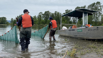
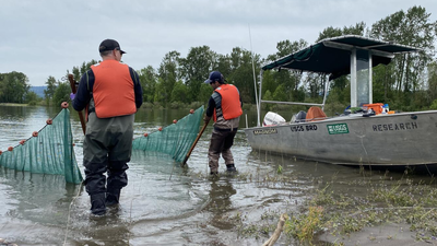
Researchers Brian Ekstrom and Lance Downing are monitoring the islands to understand how wildlife is using the new habitat.They use beach seines to collect young fish from the shallow water around the islands. Researchers are also mapping changes to the land, studying plant growth, and recording the different species found at the site.The scientists want to learn which fish and other animals are using the islands, whether predators are present, and how productive the new habitat is compared with nearby natural areas that were not created with dredged material.
Studying future dredging sites
The Woodland Islands project is also helping researchers prepare for future sediment placement projects.A separate study is examining five possible sites along the Lower Columbia River where dredged material could be placed during maintenance work scheduled to begin in 2027.Researchers are visiting these locations now to record their existing environmental conditions before any new sediment is added.They are measuring habitat quality, water depth, and fish activity. This information can help engineers choose locations that could provide better habitat for young salmon while still allowing commercial ships to safely use the river.The baseline information will also allow researchers to compare conditions before and after future projects and determine whether the new sediment deposits actually improve the surrounding ecosystem.
Turning dredging into restoration
If long-term monitoring shows that the artificial islands provide meaningful benefits for migrating salmon, the approach could become a model for other projects across the Pacific Northwest.Instead of treating dredged sediment simply as waste that needs to be removed, river managers could use it to rebuild damaged habitats.The Woodland Islands experiment could show how a necessary maintenance activity, keeping shipping channels open, can also help restore important ecosystems and support threatened salmon populations.